


About
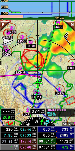
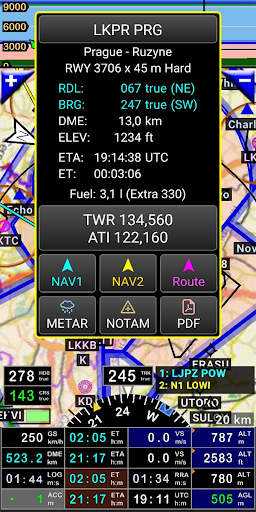
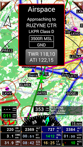
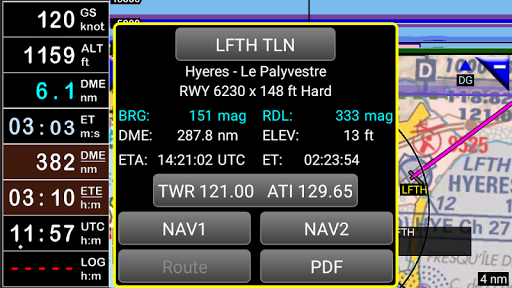
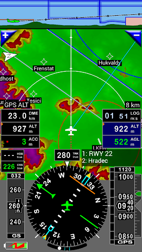
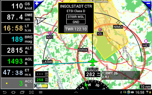
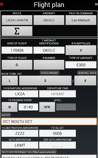
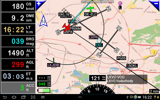
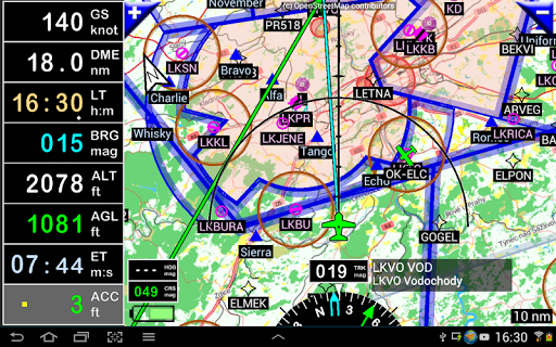
FLY is FUN is designed by pilots for pilots. FLY is FUN simplify flight preparation and improve situation awareness during flight, providing information on airspaces, reporting points, position on moving map, elevation, frequencies, railway, weather info … facilitate access to airfields related PDF document. Application also displays NOTAMs and data from rainfall radars. FLY is FUN simulates ILS approach, VOR, NDB, DME, Marker beacons, RNAV navigation and Marker beacons warnings, without ILS/VOR/NDB/RNAV equipment on board. You can test FLY is FUN for free during few days. At the end of the trial period, pilot is invited to subscribe and pay an annual fees. Doing it, he get the right of using the application "as it is" and contribute to development effort. FLY is FUN allows: - Creating and modifying routes using "drag and drop", "rubber band" - Getting warnings, alarms and radio info before entering controlled or special use airspaces, approaching points - Performing route planning, evaluating distance, time and fuel consumption (depending on wind and aircraft characteristics) - Displaying route, bearing, trace on moving map - Visualizing airspace - Getting dynamic terrain map (colors depending of elevation above ground level) - STRATUX support - Creating and exporting Flight Plan - Creating and exporting Flight log - Creating, importing or exporting routes, waypoints, RWY, airspace (Garmin .gpx, .kml, txt, OpenAir) - Recording the flight and playing it back with Google Earth - Sunset / Sunrise - Getting weather forecast along the route - Rainfall radar - Wind displaying - Calculating distance between 2 points on the map - VACs - Notepad … All main screens (5 portrait and 5 landscape could easily be customized. Pilot can choose from around 100 values to display. Example: - Altitude GPS or barometric - Ground speed - Bearing - Vertical speed - DME to next point / destination - Estimated time to next point / destination - Time since departure - Stop watch … Displayed information could be customized too depending of users preferences (VFR, IFR or both) and zoom level. The more you zoom IN, the more detail, information, waypoints,.. you see Logbook The integrated logbook, allows recording: - Duration since departure time - Departure and arrival time - Departure and arrival airport - Flight track (it is possible to export it as .kml or .gpx and to replay it) - Used aircraft - Pilot(s) and copilots in charge - Distance, average speed, maximum speed … Navigation data available from open source database are updated according AIRAC cycles. Charts and elevation dta Free charts and elevation data are available for most of countries and could be imported directly via the application store. Other charts could be created and imported by the pilot itself or made on request available as commercial service. Pilots could select the most appropriate charts: free open source charts as well as commercial charts as ICAO, Cartabossy, SkyVector, FAA sectional and terminal charts… VACs and PDF files VAC and AIP infos are available for more than 50 countries User can easily attach your own PDF files. Usage of external GPS connected via Bluetooth is possible User guide: http://www.funair.cz/downloads/manuals/flyisfun.pdf If you have any suggestion to improve this application or you find some bug please visit www.flyisfun.com Use this application for VFR FLYING ONLY!!! We are not responsible for any use of this application.
Info
Release
Jan 20, 2012
Last Updates
Added 4 transmission protocols for setting frequencies to the radio via Bluetooth. Now the app supports KRT2, Trig and Garmin (+ compatible). Preferences / VHF
Rating
PEGI 3
Genre
Maps & Navigation


Reviews
A total disrespect for all who already had bought the lifetime licence. Opposed to what i did in the past by recommending this app, now i only have the option to disrecommend this APP. What a lack of character... Pretty sad...
A Google user
I have bought the app FiF 15.0 with the LIFETIME licence. I understand your monetary policy change, but it should be for NEW customers only. It is highly unprofessional, I believe even against customer protection regulations, to sell the product with lifetime licence and cancel that afterwards. As pilot I have used app for flying regularly, but now I find it highly unreliable as I'm not able to update new database. I am very disappointed with your business politics, I could find cracked version when I at first downloaded it, but I've decided to buy and support your development. Even if I buy yearly licence, how I could be sure that you will not change again your monetary policy to monthly or daily payment for licence? This is not way how to do business.
A Google user
I bought FIF with unlocker some years ago. Now I want to change the phone where I use the app, and I cannot, I have to buy it again. This not what I bought! I only want to move the app and data to new device, does not matter if my database is old, but I cannot, I have to pay again. Frustrating. Many of as support this app in its origines, and now we receive this in payment for that support. Pay again!!!! Probably next update will be, pay each time you run the app.
A Google user
Very very very disappointed Petr. We supported you from start and now can no longer use this app. Where is my life long licence that I paid for? Please do not tell me I can use it forever as long as I do not need new database and features. Well the app somehow deleted my old database. How and from where can I install an old database without the app forcing me to a subscription now?? Also a note about subscription. I still have a life long subscription to Sygic car navigation, even though they introduced subscription for new customers, That is what reputable companies do. You were not well advised here. Anyways please respond how to use the app with an old database which is not there?
A Google user
With open source maps, load-your-own ERSA & not CASA certified, it used to be a cheap & cheerful VFR companion. But with each update (all support to EU & USA) it becomes ever more troublesome. For downunder, add all the wierd terminology to mesmerizing and ballooning array of controls, I'm sad to say it is fast becoming a liability in the cockpit.
A Google user
Been using this app for several years and never had a problem. Every light sport aviator should try it. Catch ya Ray. OZ.
A Google user
Great app. Very simple to use. I've been using it for two years around New York City air spaces and LaGuardia and JFK. Works great, highly intuitive.
A Google user
Became from 5 star great app to inflight forced update useless software. Sad development of a initially great idea. Good for a Sim on the ground but don't use for real flying.
Alexander Dorn
I used the app a few years back during my ppl cross country flights and it was of great help, especially in navigating through the airspaces. That's great value for the money. It would have been nice for the graphics to move smoothly during navigation like for example: waze or Google maps...but I got used with it.
Ionut Patrascu
Paid for a licence and it is now asking me for a subscription payment. - explanation was acceptable, however, in normal circumstances, a license would not be revoked in this manner. I suggest adding additional features and selling new licenses. Customers who bought licenses bootstrapped your business providing the capital to grow. More importantly, however, is the loss of trust from customers which is precious currency.
A Google user
Danger! Estonian airspace incorrect as of mid-April! Avoid usage until fixed! Works like a charm. Much better than some other software from bigger producers. The new logbook feature with GPS track export is nice.
Jüri Kaljundi